
Recently System Activities
- Levent Koç
- Levent Koç uploaded a summit registry.
- 19.10.2026 13:51
- Levent Koç
- Levent Koç uploaded a summit registry.
- 19.10.2026 13:50
- Levent Koç
- Levent Koç uploaded a summit registry.
- 19.10.2026 13:49
- Levent Koç
- Levent Koç uploaded a summit registry.
- 19.10.2026 13:48
- Hüseyin Turan
- Hüseyin Turan uploaded a photo.
- 19.10.2026 12:27
- Sema Kızılaslan
- Sema Kızılaslan uploaded a photo.
- 19.10.2026 11:44
- Ramazan Eroğlu
- Ramazan Eroğlu uploaded a summit registry.
- 19.10.2026 11:32
- Ramazan Eroğlu
- Ramazan Eroğlu uploaded a summit registry.
- 19.10.2026 11:31
- Ömer Faruk Gülşen
- Ömer Faruk Gülşen uploaded a photo.
- 19.10.2026 10:39
- Ömer Faruk Gülşen
- Ömer Faruk Gülşen uploaded a photo.
- 19.10.2026 10:39



- Muhindo Geoffrey
 Uganda, Kampala
-
- Mount: 1
- 3.000 m. Above: 3
- 3.000 m. Below: 0
- Mount
- 1
- 2.500 m
- 3.000 m
- 5.000 m
- 1
- 7.000 m
- 8.000 m
- Summit
- 3
- 2.500 m
- 3.000 m
- 5.000 m
- 3
- 7.000 m
- 8.000 m
- Muhindo Geoffrey uploaded a blog post.
- Category : Mountaineering
- Rwenzori mountains trekking in Uganda
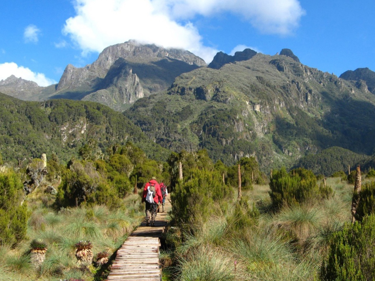
- The Rwenzori mountains are a 996km2 range stretching 120 kilometres (75 mi) in length and 65 kilometres (40 mi) in width making it Africa’s biggest mountain range. It consists of six massifs separated by deep gorges: Mount Stanley (5,109 metres (16,762 ft)), Mount Speke (4,890 metres (16,040 ft)), Mount Baker (4,843 metres (15,889 ft)), Mount Emin (4,798 metres (15,741 ft)), Mount Gessi (4,715 metres (15,469 ft)) and Mount Luigi di Savoia (4,627 metres (15,180 ft)). Mount Stanley has several subsidiary summits, with Margherita Peak being the highest point which is bisected by the border with DR Congo. The Rwenzori mountains are not volcanic like East Africa’s other major mountains but is a block of rock upfaulted through the floor of the Western Rift Valley. The Rwenzori mountains were christened the “Mountains of the Moon” by the Alexandrine geographer Ptolemy in AD 150. The explorer Henry Stanley placed the Rwenzori mountains on the map on 24th May 1888. He labelled it ‘Ruwenzori’, a local name which he recorded as meaning “Rain-Maker” or “Cloud-King.” The Rwenzori mountains – the fabled Mountains of the Moon – lie in western Uganda along the Uganda-Congo border. The equatorial snow peaks include the third highest point in Africa, while the lower slopes are blanketed in moorland, bamboo and rich, moist montane forest. Huge tree-heathers and colourful mosses are draped across the mountainside with giant lobelias and “everlasting flowers”, creating an enchanting, fairytale scene. Rwenzori Mountains National Park protects the highest parts of the 120km-long and 65km-wide Rwenzori mountain range. The national park hosts 70 mammals and 217 bird species including 19 Albertine Rift endemics, as well as some of the world’s rarest vegetation. The Rwenzori mountains also have over 20 lakes in their beautiful valleys with the nearest and first lake being Lake Mahoma (3,000m asl) then Lake Bujuku (3,962m asl) which lies in the beautiful ice curved Bujuku valley along the Central circuit trail. The Rwenzori mountains are a world-class technical hiking and mountaineering destination. No wonder, for all the past years we have been handling and organising treks to the Rwenzori mountains of the moon, all our previous climbers with experience in Kilimanjaro, Annapurna, Arapat and Mount Kenya have rated the Rwenzori mountains as a more difficult hiking destination. Several treks are available summit Margherita peak from the 7 days trek, 8 days trek, 9 days trek with 3 peaks and 12 day treks to summit 4 to 10 peaks. Shorter, non-technical treks are also possible to hike the surrounding peaks all fully organised by Bujuku Eco Tours. There are several climbing routes on Rwenzori mountains with 3 major routes to summit the peaks and several other routes for nature walks and short treks. For those who prefer something a little less strenuous, neighbouring Bakonzo villages offer nature walks, homestead visits home cultural performances and accommodation, including home-cooked local cuisine. Most treks to the Rwenzori mountains begin and end in Kasese town the largest town in the Rwenzori region.
Log in or register for more content!
Recently Added Summit Registries
- Levent Koç
-
 Mounts Bolkar Kara Hill - Türkiye, Icel - 3.266 m.
 - Summit Date: 18.10.2026
- Levent Koç
-
Mounts Bolkar Geyikdede Hill - Türkiye, Icel - 3.283 m.
- Summit Date: 18.10.2026
- Levent Koç
-
Mounts Bolkar Gollucebasi Hill - Türkiye, Nigde - 3.137 m.
- Summit Date: 18.10.2026
- Levent Koç
-
Mounts Bolkar Gökboyun Hill - Türkiye, Nigde - 2.925 m.
- Summit Date: 18.10.2026
- Ramazan Eroğlu
-
Mount Degirmen - Türkiye, Kayseri - 2.539 m.
- Summit Date: 18.10.2026
Recently Added Mountains
- Mount Delekor
- Türkiye, Van - 3.020 m.
- Coordinates : 39.0°11.0'57.8"N 43.0°26.0'59.1"E
- Mounts Aladaglar Cifte Zirve
- Türkiye, Kayseri - 3.113 m.
- Coordinates : 37.0°59.0'27.1"N 35.0°13.0'3.7"E
- Mounts Aladaglar Minas Hill
- Türkiye, Kayseri - 2.790 m.
- Coordinates : 38.0°0.0'23.1"N 35.0°11.0'34.2"E
- Mount Alpamayo
 Peru, Huaraz - 5.947 m.
- Coordinates : 8.0°52.0'44.2"S 77.0°39.0'13.0"W
- Mount Ortadag
- Türkiye, Icel - 3.082 m.
- Coordinates : 37.0°19.0'11.2"N 34.0°27.0'28.7"E
Upcoming Mountain Activities
- Mount Kizilgol
- Türkiye, Kayseri - 2.692 m.
- Date: 23.10.2026 - 25.10.2026
- Mount Deliktas
- Türkiye, Kayseri - 2.673 m.
- Date: 23.10.2026 - 25.10.2026
- Mount Buyuk Sig
- Türkiye, Kayseri - 2.576 m.
- Date: 23.10.2026 - 25.10.2026
- Mount Corlavik
- Türkiye, Kayseri - 2.588 m.
- Date: 23.10.2026 - 25.10.2026
- Mount Saydas
- Türkiye, Kayseri - 2.635 m.
- Date: 23.10.2026 - 25.10.2026
